Photo credit: Masumi
Last modification: 01/19/08 19:26
Photo credit: Masumi
If you could live anywhere, where would it be? If you haven't figured it out yet, I'd prefer a lush remote Pacific island. One with high-tech jobs, a good bookstore, good schools, and a Home Depot. The irony is that no island can live up to all these criteria, even if one could afford such a thing. Hawaii has the highest cost of living of any state, and you're very lucky if you can even purchase island property outside the U.S.
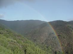
If the above picture looks like Kauai, it's not. It was taken outside our kitchen window one morning after a heavy rain shower in the Cupertino mountains. That's right, Cupertino, as in Silicon Valley, gridlock, smog, and flat. Most people never take the time to fully explore the hills around the South Bay, but that's where the beauty is. From Half Moon Bay to Santa Cruz, La Honda to Bonny Doon, the Santa Cruz mountain range is an oasis that can make you think, for a little while, that you took a wrong turn somewhere on the way to Lake Tahoe. Or Napa.
Although it's still possible to live the way Ken Kesey did, if you get too far away from the Valley floor you have to battle rain, fog, and windy mountain roads. There's no municipal water or pizza delivery, and you never know when a generator might come in handy - but that's the price you pay for fresh air and views that go on for miles. The orchards may have been replaced by office parks in Santa Clara, but up here life remains unchanged. Except for the wireless broadband and DirecTV, of course.
Montebello Ridge is part of Mount Black, the "mountain" in Mountain View. Located in unincorporated Cupertino, the area and its surrounding open space preserves are part of Santa Clara county. Wine tasters, hikers and mountain bikers are invited to enjoy the local Pichetti and Ridge wineries on their way to the summit (2600').
For more on this area and others like it, catch Bay Area Backroads, Sat & Sun nights on KRON-TV. Speaking of television:
![]() List Of DTV
Television Stations Currently Receivable Over The Air From Mt Black :
(12/26/09)
List Of DTV
Television Stations Currently Receivable Over The Air From Mt Black :
(12/26/09)
| Call | Ch | Network | City | Broadcast Location | Notes | Signal Strength |
| KAXT | 1.1-20 | Shared | San Jose | Aborn Rd, San Jose | Low power, 15KW, 1-1 EPG, Misc | |
| KTVU | 2.1-2 | FOX | Oakland | Mission Peak, Fremont | "TV36", Awaiting Update, 1MW | 28% |
| KCRA | 3.1-2 | NBC | Sacramento | Walnut Grove | 100kW | 22% |
| KRON | 4.1-2 | Independent | San Francisco | Sutro Tower, SF | 1MW | |
| KPIX | 5.1 | CBS | San Francisco | Sutro Tower. SF | Awaiting Update, 1MW | 43% |
| KGO | 7.1-2 | ABC | San Francisco | Sutro Tower, SF | 72 kW | |
| KQED | 9.1-3 | PBS | San Francisco | Sutro Tower, SF | 777 kW | 36% |
| KXTV | 10.1-2 | ABC | Sacramento | Walnut Grove | 34.5 kW | 13% |
| KDTV | 14.1 | UNI | San Francisco | San Bruno Mtn | Spanish, 476.3kW | 63% |
| KFSF | 14.2 | Telefutura | ? | ? | ? | |
| KOFY | 20.1,.4 | Shared | San Francisco | Sutro Tower, SF | Awaiting Update, 383kW | 35% |
| KRCB | 22.1-12,.101-103 | Shared | Cotati | Glen Ellen | Awaiting Update, 105kW | 42% |
| KMAX | 31.1 | CBS | Sacramento | Walnut Grove | Awaiting Update, 1MW, active? | 21% |
| KMTP | 32.1-2,.4-5 | CAS | San Francisco | Sutro Tower, SF | 500 kW, active? | 34% |
| KICU | 36.1-3 | Cox | San Jose | Mission Peak, Fremont | 550 kW | 62% |
| KCNS | 38.1-2 | Independent | San Francisco | Sutro Tower, SF | 1MW, Chinese broadcasting | |
| KTXL | 40.1-2 | Fox | Sacramento | Walnut Grove | 950 KW | |
| KTNC | 42.1-2 | TuVisión | Concord | Walnut Grove | Spanish, 40kW | 61% |
| KBCW | 44.1 | CBS | San Francisco | Sutro Tower, SF | Awaiting Update, 400kW | 28% |
| KTLN | 47.1 | TLN | Novato | Novato | Xtian, 1MW | |
| KSTS | 48.1-3 | TEL | San Jose | Mt. Alison (Fremont) | Spanish, 257kW | 73% |
| KTEH | 54.1-5 | PBS | San Jose | Milpitas | 290kW | 40% |
| KQCA | 58.1-2 | NBC | Sacramento | Walnut Grove | 600kW | 24% |
| KCSM | 60.1-3 | PBS | San Mateo | Sutro Tower, SF | 536kW, community college, weak | |
| KFSF | 66.1-2 | Telefutura | San Francisco | Sutro Tower, SF | Awaiting Update, 150kW | 26% |
| KTLN | 68.1? | TLN | Novato | Fremont Peak, Salinas | Xtian, 1MW | 47% |
(12/12/2012 Update - According to KAXT's
Electronic Program Guide on Ch. 1-1, the DTV channel line up is: )
1-1 KAXT1-13
2-1 KTVU1-2
4-1 KRON
5-1 KPIX
7-1 KGO1-2
9-1 KQED1-3
11-1 KNTV1-2
14-1 KDTV
20-1 KOFY1-2
22-1 KRCB1-3
26-1 KTSF1,3,4
32-1 KMTP1,2,5
32-6 MTPDT6
36-1 KICU1,2
38-1 KCNS1,2,4
38-5 CNSDT5
42-3 KTNC3
44-1 KBCW
48-1 KSTS
48-3 STSDT3
54-1 KQEH1-5
60-1 KCSM1-3
65-1 KKPX103
66-1 KFSF1-2
68-1 KTLN
KTSF 27 (San Bruno Mtn, Asian,
500kW) like several other
stations broadcasting near San Francisco, lies in a partial mountain shadow and
may be too weak to be received in digital. Currently in the process of
being upgraded to 858kW,
your best bet for now is to watch it as a Local
Channel via
DirecTV (current channel lineup incl. KBCW, KFTY, KGO, KCNS, KCSM, KDTV,
KFSF, KICU, KNTV, KOFY, KPIX, KRCB, KRON, KTEH, KTSF, KSTS, KTLN, KTVU &
KQED.)
KFOG 104.5 FM (another Sutro
Tower station in the shadow of Mt. Black) rebroadcasts its signal to San Jose
via a 3.1 kW repeater on
the Ridge as KFFG 97.7 FM, Los
Altos. ![]() For a
list of all the analog & digital transmitters in the US for Google Earth (as of
2010), click here.
For a
list of all the analog & digital transmitters in the US for Google Earth (as of
2010), click here.
Places to Visit
Blackberry Farm
City of Cupertino
Bay Area Backroads
SiliconValley.com
The Cupertino Courier
Bay Area Metro
San Jose Mercury News
Parks & Recreation
Midpeninsula Regional Open Space
Stevens Creek County Park
Joseph D. Grant County Park (across the bay on Mt. Hamilton)
Fire & Police
Stevens Creek Volunteer Fire Dep't
Santa Clara County
FireSafe Council (Lexington Hills)
Santa Clara County Fire Dep't
Area Crime Reports
Local Resources
Black Mountain on Wikipedia
The Cupertino Courier
The Cupertino News
Cupertino Patch e-newsletter
Computer Recycling
Free
Compost
KMVT 15 Community Television
KKUP Cupertino Commercial Free People's Radio
91.5 FM
WQGH Streaming Radio Cupertino 1670 AM
KMVT 15 Silicon Calley Community Media,
producers of "The Better Part"
KCAT Los Gatos/Monte Sereno Community
Television
Stevens Creek Volunteer Fire Dept
Local Wineries
Vidovich Vineyards
Ridge Vineyards
Fellom Ranch Vineyards
Naumann Vineyards
R&W Vineyards
Picchetti Winery
Neighboring Wineries
Cooper-Garrod
Vineyards
House Family Vineyards
Mount Eden Vineyards
Kathryn Kennedy Winery
The Mountain Winery (formerly Paul
Masson)
Saratoga Wineries & Beyond
Savannah Chanelle Vineyards
Big Basin Vineyards
Domain Eden
Santa Cruz Mountains Winegrowers Association
Bay Area Air Quality Management District (map) Links
Air Quality
Forecasts
Bay Area Open Burn Status
Historical
Air Monitoring Data
How To
Reduce Your PM 2.5 Exposure
Cupertino 2010-2013
Air Monitoring Project (archived
report) (archived toxics)
![]() PurpleAir
Air Quality Map (user-sourced,
incl. temps & humidity)
PurpleAir
Air Quality Map (user-sourced,
incl. temps & humidity)
Environmental Groups
Bay Area For A Clean Environment (BACE) (formerly 'No Toxic Air' - Councilman Barry Chang is
on this one)
West Valley Citizens Air Watch
South Bay Quarry Library
Stevens Creek Quarry Surface Mining & Reclamation Act (SMARA)
EV Charger Finder (thanks Waidy for starting this list)
Blink Network FinderForgotten Backroads (you're on your own here!)
Balboa Rd
Baccaglio Way
Casa de Pinos
Coyote Ridge Trail
Cruz Perez Way
El Cerrito Rd
Kristen Drive
Mikulaco Rd
Montebello Terrace
Old Raffa Rd
Stevens Creek Tony Look Trail
Water Wheel Trail
SCCGov Interactive
GIS Map Viewer,
Surveyor Map Viewer
Santa Clara County
Assessor's Office Real Property Search ,
Clerk-Recorder Official
Records,
Surveyor's Office
Weather Stations
Weather Underground
Davis WeatherLink
Mt. Eden
Stevens Canyon
Swiss Creek
Casa de Pinos
Page Mill
Santa Clara Valley Water District
PurpleAir
Air Quality Map (incl. temps &
humidity)
Fun Stuff
Weather Radar
3-Day Forecast
7-Day Forecast
NOAA
Los Altos
PG&E Electrical System Outage Map
Bay Area Earthquake Reports
USGS ENS Notification Service
USGS Quaternary Faults Database
Berkeley
Real-Time Interactive Earthquake Map
Bay Area Air Quality &
Temperature Reports
Pacific Tsunami Warning Center
What's
a 'Cupertino'?
(with apologies to Prof. Foglio's
Girl Genius)
